The Italian Dolomites are well known for their impressive jagged peaks and kilometres of picturesque hiking trails. Here’s what you need to know before hiking Alta Via 1.

The Italian Dolomites are well known for their impressive jagged peaks and kilometres of picturesque hiking trails. Here’s what you need to know before hiking Alta Via 1.


Do you like beautiful landscapes, road trips and hiking? If you answered yes, then you owe it yourself to make the journey to Norway’s Lofoten Islands – before everyone discovers one of the most beautiful places I’ve ever seen.
The Lofoten Islands – located within the Arctic Circle – offers kilometres of spectacular mountain landscapes scattered with quaint fishermen cottages and bridges spanning azure water. And one of the best ways to reach them is by pulling on your hiking boots and navigating muddy and steep mountain sides to see them. You won’t be disappointed.

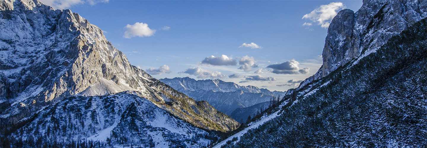
If you only have time to do one hike in the Lofoten Islands, make sure it’s the Reinebringen hike.
The Reinebringen peak is 448 metres high and getting there is pretty much straight up. It’s very popular these days so expect crowds.

If you’re scared of heights, don’t do this hike. I’m not scared of heights but there were a few moments when I looked down and realised the sheer drop below me and if I put a foot wrong I was going to end up all the way down a steep cliff. But I continued on with the help of a Portuguese hiker I met on the trail who helped me get up some of the slippery rock sections.
I made it to the top in about an hour, but it was a hard slog. But the views were absolutely worth it – they actually take your breath away! You get a spectacular view over Reine – seeing how the bridges link up all the islands. There’s also a brilliant crater filled with water.

If you keep going up to the peaks on your left and right, you can get 360 degree views but it’s a very steep and tricky climb to some of higher peaks.

The Kvalvika Beach hike starts opposite a small parking space, but get there early as the hike is popular.

The start of the trail can get pretty muddy – but you’ll get used to all the mud after a few days on the Lofoten Islands! The first section is well marked and the muddiest sections have wooden planks laid over them.

Be warned, the trail itself is not that well marked once you’re clear of the trees and on the hillsides. I had to double back a couple of times, particularly making my way across the pass as you start the descent down to the beach.

The descent down to the beach is steep and slippery. It’s very slow going and hard to keep to any sort of trail. But even if you don’t make it all the way down, you can catch a good view of the beach from about halfway down the pass.
Plan the hike to take about 90 minutes to two hours each way depending on how well you can stick to the trail and negotiate the downward hike to the beach.

The Offeysoykammen Peak starts just off the E10 Highway. The hillside overlooks the Nappstraumen waters and a hillside with small lakes. If you get a summit free of cloud though – you’re very lucky.
To get to the starting point, look for the road named Skreda. Coming from the south, it’s just past the Nappstaumen tunnel on your right. Park at the end of this road, cross the E10 and look for a small opening that marks the start of the trail.
The climb starts off fairly easily but once you’re out of the trees – it gets steeper and steeper and then it’s pretty much straight up. It’s also one of those peaks where you think you’re nearly at the summit, then you realise you have much more to go.
In the information I read, the trail is marked as easy. I would say it’s moderate at a minimum as it’s fairly steep. But it’s a good short hike with panoramic views. Expect the trail to take about 90 minutes up.

Another hike you can do is the Bunes Beach trail. The trail starts from the Vinstad village. You’ll need to take a ferry there from Reine – ferries leave several times a day during summer and the timetable is posted on a signboard at the Reine harbour.
The return Bunes Beach hike will take around three hours.
A few Americans I met out hiking also said the hike starting from the row of fish heads (you’re sure to spot them) across the road from the carpark serving the Å township has rewarding views but features a whole lot of mud. Maybe bring a spare pair of shoes and socks.
How to get to the Lofoten Islands

I reached the Lofoten Islands from Sweden’s Stockholm Arlanda Airport, but you can also fly in via Norwegian cities. I flew into the town of Leknes via Bodo, and I exited also via Bodo to Stavanger.
You can also take a ship from Bodo to Moskenes on the southern tip of the islands but I’m told it’s a rough crossing – so if you get sea sick like me, stick to flying.
There’s regular flights offered by the airline Wideroe to reach Lofoten Islands from Bodo. You can fly into either Leknes or Svolvaer.
Leknes is a small town and there’s not much to see, but there’s a couple of car rental agencies represented at the airport and in town. It’s best to book ahead.
Accommodation is limited and can be on the expensive side, so I opted for an AirBnB accommodation near the Fredvang Bridge and it was an excellent choice. I stayed with a lovely family who made me feel incredibly welcome and helped me find hikes to do.
The Lofoten Islands is easy to get around. The main highway is the E10 and goes the length of the islands. The main towns are well marked.

Things you should know

Canberra is left off most traveller’s itineraries for the bright lights of Sydney and Melbourne and the marine life of the Great Barrier Reef. But the Canberra region is blessed with a couple of very good national parks and nature reserves with well-maintained and scenic trails.

Throughout my travels, I’ve been to a lot of volcanoes. Some are active, some are dormant – and one was a mud volcano. Here’s a guide to my favourite volcanoes around the world.

For a volcano that will test you physically as well as offer great views, head to Concepcion Volcano on Nicaragua’s Ometepe Island.
It’s a steep, sweaty climb but you get great views of the whole island from up top and stare down into a sulphur smoke emitting volcanic crater.
The return hike takes about eight hours including lunch and photo stops.
But the view at the top is totally worth the burning calves and sweat soaked clothes.

You can hike the lava lake created by the Kilauea Volcano on the Big Island of Hawaii. The Kilauea Iki hike starts in humid forest before descending into a flat and exposed lava lake.
It’s an easy hike that only takes a couple of hours and is a great introduction to the Hawai’i Volcanoes National Park. Before or after your hike, check out the Halema‘uma‘u Crater and the Thurston Lava Tube. It’s worth seeing the Halema‘uma‘u Crater during both the day and night. At night, the crater glows red from the lava in its base.

The Haleakala Volcano is best to check out at sunrise – it offers one of the best sunrises I’ve seen, even though it gets really cold up there!
It was great to drive up the winding road of the mountain in the dark when the stars were still out and shining brightly due to the lack of light pollution up there. It was beautiful to watch as the sun rose up from behind the crater above the clouds. You’re 3000 metres above sea level up here!
It was even better when the crowds had cleared out as the sky lit up further and you were pretty much on your own taking in the view of the crater.
For a volcano of a different kind (and an addition to your most random travel experiences), head to Cartagena in Colombia to check out the El Totumo Mud Volcano. You can bathe in the volcano’s warm, dense mud and get a massage from locals while floating in the mud. As you can see from the photo, it was actually hilarious in a random kind of way.

The appeal of this particular volcano is you can go inside it. The Thrihnukagigur Volcano (try saying that one!) is located about a 40 minute drive from Iceland’s capital Reyjkavik. It last erupted about 4,000 years ago and left behind a hollow crater.

The Inside the Volcano tour includes a 45 minute hike from the carpark up to the side of the crater, then you’re lowered inside to have a look around.
A fantastic experience and one for the bucket list.

You can see the Agua Volcano from most places in the Guatemalan city of Antigua, looming majestically over the beautiful colonial buildings. Next to the Agua Volcano is the Pacaya Volcano, which is highly active and regularly spews out lava.
You can hike both of these volcanoes for great views of Antigua and other volcanoes.

One of the world’s most active volcanoes is Mt Etna, located on Sicily’s east coast just outside the city of Catania. This is one of the more accessible volcanoes with a number of tours offered suited for all fitness levels.