
I bet you didn’t know there’s more than a dozen mountains you can hike near Brisbane.
And while they are no taller than 1,400 metres – these are still real mountains (by Australian standards!). They will challenge you, get your heart rate going and you’ll enjoy epic views from the summit. And you’ve got a pretty good chance of having these mountain summits all to yourself.
You’ll hear bird calls, creeks dancing over rocks, the wind through the trees. You’ll see the surrounding mountains, green valleys, and find the perfect rocky outcrop for a bite to eat with a view. You’ll feel tiny exposed on a huge cliff face or admire early morning fog shifting through the trees.
So if you’re looking for the best mountains to hike near Brisbane, I’ve done the hard work for you. Here’s my selection of the very best mountains near Brisbane.
What are you waiting for? Lace up your hiking boots, fill your backpack with tasty hiking snacks and water, and head to the mountains this weekend.
Mt Barney
Difficulty Rating: Very hard
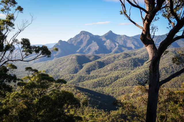
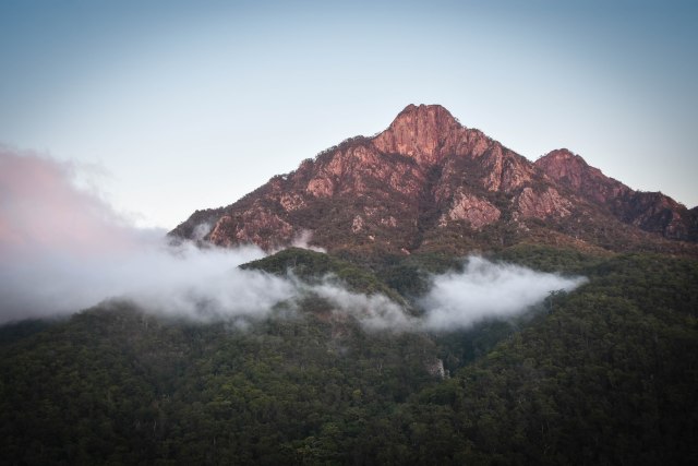
Mt Barney is the most epic of all the mountains near Brisbane. With more than 10 different routes to the top of this rugged massif’s many peaks, you can choose your own adventure every time you hike.
But standing at 1,359m tall at its highest point, Mt Barney is no easy hike and the return hike can take between 8-12 hours depending on your fitness levels.
The most popular route – and the best route for first timers – is up and down the South Ridge to the 1,351m East Peak via the saddle and campground called Rum Jungle.
If you’re confident with exposure, navigation and vertical rock scrambling, then go up South East Ridge and down South Ridge.


If you camp in the saddle between East and West Peak and you’ll likely enjoy a cloud forest on morning.
How to get there? Start the hike from Yellow Pinch carpark in Mt Barney National Park, off Upper Logan Road, near Rathdowney. The drive to the trailhead is about 2 hours from Brisbane. Head up the fire trail from the carpark, go through the turnstile, and head right. If you’re going up South East Ridge, the trail starts shortly after the turnstile on your right. The start of the South Ridge is further along the fire trail. Cross the concrete causeway, and continue on for about 20 minutes until you see the sign on your right heading up South Ridge.
The South and South East Ridge trails are sporadically marked so you will need some navigational savvy. It’s best to go with someone who has done the mountain before if this is your first ascent up Mt Barney.
How far? The hike will take about 8-12 hours return depending on your fitness level and navigational skills. Start early (no later than 8am) – but don’t go if rain is forecast or it’s rained overnight.
Mt Maroon
Difficulty Rating: Very hard
Mt Maroon is also located in Mt Barney National Park – in the shadow of Mt Barney itself.
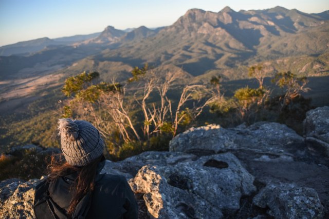
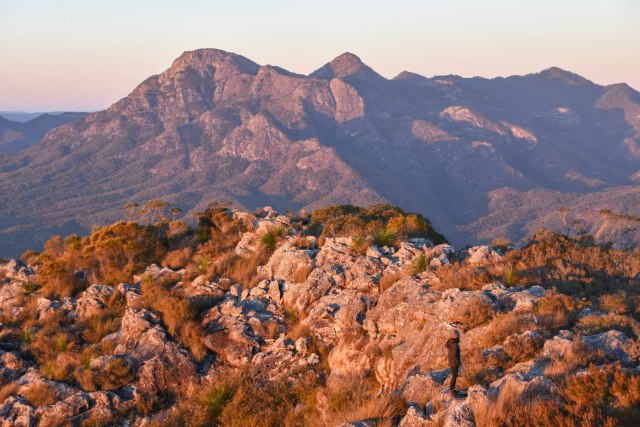
Mt Maroon is my go to mountain if I’m craving an epic sunrise. You’ll get a 360-degree view of the Scenic Rim region, as well as a close up of Mt Barney’s rugged slopes.
It’s a steep hike up though with only brief respites in between, and you’ll also need to get your rock scrambling on.
Fit hikers with sound navigation skills can reach the summit in as little as 90 minutes. The trail is sporadically marked so you’ll need to rely on your navigation skill set.
Early birds are likely to have the mountain all to themselves as an orange glow lights up the mountain top and the valley below.
There’s lots of mountain goat opportunities as you explore the summit and check out the views from all directions atop the 967m summit.
How to get there? Start the hike from the carpark off Cotswold Road (left off Boonah-Rathdowney Road), near Rathdowney. Be respectful as the start of the hike starts on private land. The drive from Brisbane is about 2 hours.
How far? The hike will take about 4-5 hours return.

Flinders Peak
Difficulty Rating: Moderate-Hard
If this is your first time tackling rugged mountain peaks near Brisbane, then Flinders Peak is a good starting point.
Flinders Peak is 677 metres high, and has two peaks. The hike is steep in places, and involves small sections of rock scrambling near the top.
How to get there? The hike starts from the Flinders Plum Picnic Area off Mt Flinders Road, Peak Crossing. The drive will take about 90 minutes from Brisbane.
How far? The hike will take about 3-4 hours return.

Mt Superbus
Difficulty Rating: Very Hard
Mt Superbus is the highest mountain in south east Queensland standing at 1,375 metres.
Sadly there’s no views at the top – but Superbus makes up for the lack of views with its lush rainforest scenery approaching from the Teviot Gap side. And there’s even a plane crash for experienced hikers to find just below the summit of the south peak.
Mt Superbus is suited only for the very navigationally savvy as there is no tracks or signs and only a rough footpad that can be easily lost.
How to get there? Start from Head Road just past Teviot Falls near Killarney and follow the rough footpad up the slope. The drive out will take about two hours from Brisbane.
How far? The hike will take between 6-8 hours return depending on your navigational ability and fitness.

Mt May
Difficulty Rating: Hard
Mt May is a mountain that undeservedly doesn’t get a lot of attention – but that just means you’ll easily find your own little piece of solitude – 836 metres up.
Mt May is quite the epic mountain – with not just one, but two peaks. Start on the North Peak and you’ll find perfect rocky vantage points looking out to Mt Maroon and Maroon Dam.
On the South Peak, you have views out to Mt Barney and into the picturesque valleys below Mt May.
If you want to hit up Mt May for sunrise or sunset, you can set up camp next to the trailhead.
How to get there? Start the hike from the Waterfall Creek Reserve campground, located off Newman Road, Maroon. There’s no signs for the start of the hike so you’ll need to find the rough footpad behind the campground that leads steeply up the mountain. The drive will take about 2 hours from Brisbane.
How far? The hike will take about 4 hours return. The track is a loop that comes out onto a fire trail. If you’re after a bigger day – combine this with a trek to the Upper Portals in the foothills of Mt Barney.


Mt Greville
Difficulty Rating: Hard
Mt Greville (767m) is a choose your own adventure mountain with three routes up its unique slopes. While there’s no views at the summit – there are spectacular views from the top of the South East Ridge and near the entrance to Waterfall Gorge at Slab Rock.
The most scenic routes are up Palm and Waterfall gorges, which are populated by palm trees framed by the sheer cliffs of the gorges.
Signs only mark the beginning of the routes, so you’ll need some navigational knowledge to follow footpads and the mountain’s natural ridgelines to ascend.
How to get there? Head down Lake Moogerah Road and onto the gravel Mt Greville Road, Moogerah. There’s a small carpark a couple of hundred metres down the road on the right and then follow the signs to locate the trailhead. The drive is about an hour and 45 minutes from Brisbane.
How far? Allow 4-5 hours for the return trip.

Mt Cordeaux & Bare Rock
Difficulty Rating: Easy-Moderate
Mt Cordeaux is a great mountain for beginner hikers with a graded track extending all the way up to just below the summit. But while you don’t get up to the narrow summit, you’ll reach an epic viewpoint just below it for spectacular views extending over Main Range National Park and over to Mt Mitchell. On a clear day, you can even see Brisbane City.
If you’ve still got some energy left in the tank, then you can hike a little further to Bare Rock. The route is also on a graded track and will take you to a rocky outcrop with a view out to the Ramparts.
How to get there? Mt Cordeaux is located off the Cunningham Highway in Main Range National Park, near Aratula. There’s a signposted carpark on your right as you come through Cunningham’s Gap. You can access Mt Cordeaux (as well as adjacent Mt Mitchell) from here. The drive will take about 90 minutes from Brisbane.
How far? The hike to Mt Cordeaux will take about 3 hours return. If you plan to continue onto Bare Rock, allow a total of 4 hours return.
Essential Gear & Safety Advice
If you’re heading out to hike one of these mountains, make sure you check the weather forecast before you go and consider going another day if rain if forecast. Remember the weather can deteriorate quickly in the mountains.
Plan to start early and always tell something where you’re going and what time you plan to be back. On some areas of these mountains, there’s no phone reception. It’s best to head out with a friend or two – and even better if you can go with someone who’s done the mountain before.
Most of the mountains listed are not graded tracks and you’ll need some navigational knowledge to find your way up.
Below are the items you should carry in your backpack for each of these hikes.
- Hiking shoes
- Headlamp
- 2-3L of water and Hydralyte sachets
- Snacks such as fruit and candy (and lunch if going for a hike longer than 3 hours return)
- Camera
- A hiking buddy (or two)
- Maps.me app with Brisbane area downloaded
- Rainjacket in case of cold or rain at the summit
- Long pants (some parts of the tracks are narrow and overgrown with vegetation and you may need to slide down steep sections of rock on the descents)
- Hat and sunscreen
- Insect repellent for ticks and leeches
- First aid kit
- Snake bandage and gaiters in the summer months